4/23/2010

Maya: Converting a 3d-mesh to a Heightfield, Part 1

This tutorial walks through the process of sculpting a basic 3d terrain in Maya with the Mesh>Sculpt Geometry Tool, and then the process of creating a 2d greyscale height-map from that object. We will then import that object into L3DT as a design map and run it through the terrain algorithms to generate a detailed height-map that has cliffs, erosion effects, climate-map layouts, and procedural textures applied.

Details are under each image:


In step one, I have crated a poly plane that is 10 maya units by 10 maya units, and has 10x10 subdivisions. I have also created a point light (and moved it a little to one side), and also turned surfaces and lighting on (this helps in sculpting).


8 Things You Should Know About Concentrating

http://howtogetfocused.com/chapters/8-things-everybody-ought-to-know-about-concentrating/

This is a really good selection from the author's book, and include things everyone should read, integrate, and be able to express in their own terms. The pic in the article is well done CG as well:


I have a few things to post in the near future, starting with a quick Maya tutorial about converting a 3d-mesh poly terrain to a 2d greyscale height-map. Many game engines and 3d tools like L3DT use height-maps as the base for push/pull and scultping tools. This question came up on the Bundysoft L3DT forums (http://www.bundysoft.com/phpBB2/viewtopic.php?t=1472) and it seems a visual tutorial would be a great resource.

1/11/2010

Puting some work into the 3d atlas project for the Earthdawn setting today. Should have some concept art up soon. Also did an interview with MORDOM of the Earthdawn community blog about my sculpture of Garlthik One-eye, magistrate of Kratas, done for my figure Modeling course:

http://earthdawn.blogspot.com/2010/01/garlthik-one-eye-sculpture-working.html


Earthdawn Blog: Garlthik One-Eye sculpture working process
earthdawn.blogspot.com
You already know that Telarus creates awesome Earthdawn stuff. But with his last project he did in his modeling class, he surpassed himself. I contacted him to tell us a little bit about the working process and to give us some insight and inspiration.

6/11/2009

Art Institute Coursework

I'd like to take a moment to show some of my work from school, as I am taking a break from the Atlas of Barsaive project for a few days.

First up we have 2 animations I made during my Intermediate Animation course with Sean Burns, an excellent stop motion and CG animator that I had the pleasure of having as an instructor.

(You may want to watch these twice, as they seem to skip near the beginning on the first load.)

The first is a reimagining of the classic "bouncing ball" animation and was the first assignment in Sean's class.


The next animation was the Final for Sean's course. At the time I was also working out my model and background for the Esozone animation.


Next we have a model based on my girlfriends hunting-knife that I made for Aaron Sturgeon's Hard Surface Modeling course. I unfortunately had to drop Aaron's course and I will be taking it again the next term he offers it.

From GA361_Project01

6/04/2009

Atlas of Barsaive 3

Here's a shot at the new Mt Bloodfire volcano. Pretty slick, eh?


Well, I probably won't save the file, this was quick work done with my wacom tablet and some of the basic L3DT tools. I plan on working at a better scale (90m per pixel) once those GeoTIFF finish downloading and unzipping. I hope I can use more of L3Dt's terrain-specific algorithms at that scale, and if so I can play around with the 'design map' to automatically place volcanoes, and such. We'll see.

Note: The 90m GeoTIFFs are going to be awkward to work with, and probably impossible to work with all-at-once. I'm thinking of working in "supertiles" of 3x3 Geotiff tiles. This gives me a 18,000x18,000 pixel workspace at a time, and allows me to edit over 12 seams (think a # symbol) at a time. Then I'll just have to deal with the larger seams, etc, etc.

L3DT is made to handle super-large terrain, with a built in mosaic feature(max rez 131,072x131,072), so even that wouldn't be loaded into memory the whole time.

Atlas of Barsaive 2

Onwards!

Still learning the new L3DT tool, and I have to say it is made of mittens and win. I have also learned that I can get 90m resolution topography of the area I'm interested in, and am currently downloading it from the CGIAR-CSI website, which has me drooling.

I'm going to whip out a few throw away concept maps with my 1Km scale source, interpolated into 500m scale. Here's the area with a false elevation color scale (click all images for full size):


Now, I'm taking that into L3DT and importing a high-res copy of the above image as the texture-map. I have also hacked L3DT's 3d rendering engine, Sapphire, with my own custom 128bit Elev scale based on the above false elevation color.

Here are 2 pics, the first with the imported texture-map (no polygon lighting), the second with the my custom height-based scale (polygon lighting by default). As you can see the results are very comparable.


The above images are over the Crimean Peninsula looking east-ish. This is the location of one of the largest Volcanoes in the Earthdawn World, Mount Bloodfire (hey, it's a Trollish name, whaddya expect?), and this view is looking towards the Named location, Deadman's Gullet. This area is inundated with volcanic activity, and most of the 'sea' is a molten bed of lava with occasional solidified rock islands.

As the game features airships, and the mining of "True Elements" this location is a hotly contested area full of air pirates, and Theran mining vedettes (stone airship, about ww1 submarine sized).

I will next be adding a rough outline of how I would like to see Mt Bloodfire look and then play around with some of the other terrain tools.

5/31/2009

Atlas of Barsaive

Hello people,

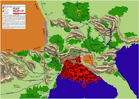
I haven't updated this blog in a while. Life got busy for a while. Well, my next project for this blog is the "Atlas of Barsaive", a mapping project for the gameworld Earthdawn (currently produced by Redbrick, and published by Mongoose Publishing, with the new 3rd Ed due in July '09).

A similar project for Tolkien's Middle Earth can be found here: http://www.me-dem.org/

So far, I have vectorized almost all of the map information present in the original FASA game line into a PDF atlas.


You can find that PDF release here:http://jaf384.aisites.com/earthdawn/Atlas_of_Barsaive_by_Telarus_KSC.pdf

Next up is to incorporate real-world DEM data (Digital Elevation Map) and align the in-game features with the real world features. Then manipulate the DEM data to add in large scale Barsavian features that don't exist on the real world map, like the Thunder Peaks mountain range, or basins for the local Jungles and Lava Seas. Then I plan on adding specific Named location from the game and then I'll apply a level of Erosion data to increase the detail.

The goal is to have a very high-quality 3d terrain of the main game-world areas which I will render in Maya, then incorporate into another PDF or Wiki project, animations, and other projects.


First up, I downloaded a set of SRTM30Plus topographical/bathymetry files from http://topex.ucsd.edu/WWW_html/srtm30_plus.html

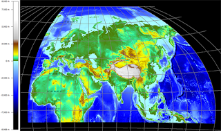
Loading these into Global Mapper, I re-project these into a Winkel Triple projection, centered on the 45degree East longitude line. This is a commonly used map projection which minimizes the distortion in the central area of the map.

I re-projected this map because the SRTM30 datafiles are a flat x-y grid, and therefore have distortion near the poles. The Winkel Triple projection (a modified azmuthal projection) is currently the standard for National Geographic society maps, so many of the intended audience will find the slight distortion familiar.

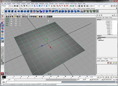
Next up, I will export a heightfield for the specific terrain I'm interested in, and then I will begin to edit the gameworld features into it with the excellent application L3DT, by Aaron Torpy. This app allows meta-map level manipulation of terrain features, robust fractal noise and erosion features, climate-based texture-splatting, robust MegaTexture generation, and a lot more! Here's a shot from L3DT's 3d rendering window of Crater Lake, Oregon:


Well, stay tuned for more in the Next Post.

10/26/2008

EsoZone Media

EsoZone 2008: Branding Animation

Best seen via the high quality version @ Youtube.

This is a short animation made with Maya and Mental Ray. It was produced in under two weeks in order to brand the site space to event participants (shown on the projector), and a shortened version will be used to brand upcoming EsoZone2008 media products. Hi-res stills are available as desktop wallpapers in a variety of resolutions. Please go to Esozone.com for more information on the event.


EsoZone Wallpapers


These wallpapers come in 2 flavors, a cloudy sky background and a fractal sky background. Please select the image size that matches your display resolution the closest. If in doubt, go for the next size up with the same aspect ratio.

EsoZone_Clouds:
"Normal" (4:3 Aspect Ratio)
1024 x 768
1280 x 960
1600 x 1200
"Widescreen" (16:9 Aspect Ratio)
1680 x 1050
2520 x 1575


EsoZone_Fractal:
"Normal" (4:3 Aspect Ratio)
1024 x 768
1280 x 960
1600 x 1200
"Widescreen" (16:9 Aspect Ratio)
1680 x 1050
2520 x 1575