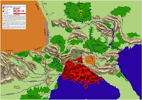
I haven't updated this blog in a while. Life got busy for a while. Well, my next project for this blog is the "Atlas of Barsaive", a mapping project for the gameworld Earthdawn (currently produced by Redbrick, and published by Mongoose Publishing, with the new 3rd Ed due in July '09).
A similar project for Tolkien's Middle Earth can be found here: http://www.me-dem.org/
So far, I have vectorized almost all of the map information present in the original FASA game line into a PDF atlas.

You can find that PDF release here:http://jaf384.aisites.com/earthdawn/Atlas_of_Barsaive_by_Telarus_KSC.pdf
Next up is to incorporate real-world DEM data (Digital Elevation Map) and align the in-game features with the real world features. Then manipulate the DEM data to add in large scale Barsavian features that don't exist on the real world map, like the Thunder Peaks mountain range, or basins for the local Jungles and Lava Seas. Then I plan on adding specific Named location from the game and then I'll apply a level of Erosion data to increase the detail.
The goal is to have a very high-quality 3d terrain of the main game-world areas which I will render in Maya, then incorporate into another PDF or Wiki project, animations, and other projects.
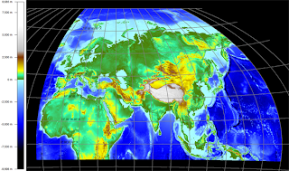
First up, I downloaded a set of SRTM30Plus topographical/bathymetry files from http://topex.ucsd.edu/WWW_html/srtm30_plus.html
 Loading these into Global Mapper, I re-project these into a Winkel Triple projection, centered on the 45degree East longitude line. This is a commonly used map projection which minimizes the distortion in the central area of the map.
I re-projected this map because the SRTM30 datafiles are a flat x-y grid, and therefore have distortion near the poles. The Winkel Triple projection (a modified azmuthal projection) is currently the standard for National Geographic society maps, so many of the intended audience will find the slight distortion familiar.
Next up, I will export a heightfield for the specific terrain I'm interested in, and then I will begin to edit the gameworld features into it with the excellent application L3DT, by Aaron Torpy. This app allows meta-map level manipulation of terrain features, robust fractal noise and erosion features, climate-based texture-splatting, robust MegaTexture generation, and a lot more! Here's a shot from L3DT's 3d rendering window of Crater Lake, Oregon:
Well, stay tuned for more in the Next Post.

4 comments:
Hey ho, it's great to see that you realize your plans as you mentioned in the interview. I posted a comment on it about your news. Great work!!
This map is terrific! It's the most attractive and thorough map of Barsaive I've seen. I've sent it to my whole group and beyond. Great work.
Hi Dylan,
Always love to hear feedback. You really really want to click on the below link ;)
http://earthdawn.blogspot.com/2011/05/enhanced-atlas-of-barsaive.html
Post a Comment